New Lands Along an Old Coast: Building the Pacific Northwest

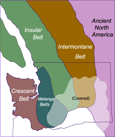
New Lands Along the Old Coast:  Building the Pacific Northwest

As Pangaea ruptured during  the birth of the Atlantic Ocean about 200 million years ago, the North American plate began drifting westward. Since that date, the western edge of the continent has grown westward as a succession of volcanic island chains and assorted ocean-floor rocks have been added along the continental margin. 

These “terranes” were then welded to the continent by a series of volcanic regimes which have developed along its western edge, in a process which continues today.  The events of these last 200 million years can be organized into four distinct episodes.

This section reconstructs the four great geologic episodes during which our land of lofty mountains and high plateaus evolved after the breakup of Pangaea.

Space photograph of the Pacific Northwest (NASA)

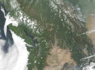
The Pacific Northwest as a geological province extends north from Washington State through British Columbia to Alaska.  Most of this region has been added to North America over the last 200 million years.  (Image: NASA)


Reeling from the Breakup of Pangaea

The breakup of the supercontinent Pangaea had enormous consequences in Washington and throughout the Pacific Northwest.  As the North American Plate was forced westward, a battle

of titans began between the westward-moving continent and the eastward-moving floor of the Pacific Ocean.  The days of geologic quiescence in the Pacific Northwest were over.  The oceanic plates of the eastern Pacific have been subducting beneath what is now Washington State until the present day

Two hundred million years ago, the floor of the eastern Pacific Ocean was composed of an oceanic plate known as the Farallon Plate (named after the Farallon Islands of offshore California).  As North America moved westward, the eastward-moving Farallon Plate was forced beneath the edge of the continent to form an active subduction zone.  This situation was entirely unstable.  The subduction of the eastward-moving Farallon Plate was unable to keep pace with the westward motion of North America. The Farallon Plate had no choice but to fragment into several “microplates.”  We call these microplates the Intermontane Plate and the Insular Plate. 


Exotic Terranes and Continental Arcs: 

The Pieces of the Puzzle

Terrane Belts

Two important geologic phenomena have accompanied subduction in the Pacific Northwest.  The first was the collision of exotic lands onto the ancient continental margin.  Geologists use the term “terrane” for large blocks of crust that share a common geologic history.  In the Pacific Northwest, many terranes are “exotic” – they have moved great distances from where they originally formed and were accreted (added) to our land by plate collision and subduction.

 At least four major terranes of oceanic rock, including the remains of two volcanic island chains and two extensive belts of ocean-floor rocks, were added to the Pacific Northwest over the last 200 million years.  As these terranes collided, the edge of the continent expanded some 400 miles westward.  These 4 terranes are named:

1. The Intermontane Belt

2. The Insular Belt

3. The Melange Belt

4. The Crescent Belt


A sketch map showing our interpretation of the original extent of the Terrane Belts extending into Washington.  The southern end of the belts is covered by younger rock of the Columbia Plateau.  This is our “best guess” at the original southern extent of the terranes.

Continental Arcs Burn through the Crust 

The second phenomenon that shaped Washington’s history was the formation of a series of continental volcanic arcs.  Remember that continental arcs are regions where molten rock (magma) intrudes and moves toward the surface, often to form volcanoes.  In the Pacific Northwest, magma intruded through the accreted terranes to form giant plutons of granite at depth and volcanic rocks at the surface.  You can think of the continental arcs as huge, elongate burned zones where magma intruded the older lands to form enormous bodies of granitic rocks at depth and volcanoes on the surface.

Four distinct continental arcs have formed through our region over the last 200 million years.  From oldest to youngest, these include:

1. The Omineca Arc

2. The Coast Range Arc

3. The Challis Arc

4. The Cascade Arc

The four great continental arcs that burned through the lands of Washington.  The arcs are shown here superimposed over the outlines of the terrane belts they intruded.  The Omineca Arc is the oldest, followed by the Coast Range, Challis, and Cascade Arcs.


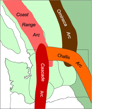
The Key to Pacific Northwest Geology:  The 4X4 History

The combination of these two processes – the accretion of four exotic terranes and the subsequent intrusion of four belts of molten rocks -- are the benchmarks along which Washington’s geologic history is organized over the last 200 million years.  To unravel Washington’s complex geologic history, you must first understand each of the four terrane belts and each of the four continental arcs.  We believe this “4X4” approach is the key to deciphering and understanding Washington’s complex geologic history.

Each of the four episodes of geologic history over the last 200 million years is named after the continental arc that dominated the episode. 

1. The Omineca Episode (180-115 million years)

2. The Coast Range Episode (115-57 million years)

3. The Challis Episode (57-37 million years)

4. The Cascade Episode (37 million years to the present).

To appreciate how these chapters of Washington’s history formed, we suggest you tackle them one at a time from oldest to youngest. 


Continue:

§ The Omineca Episode

§ The Coast Range Episode

§ The Challis Episode

§ The Cascade Episode

Return:

§ Northwest Origins Home Page

§ The Restless Earth:  A Geologic Primer

§ Dance of the Giant Continents:  The Early History of Washington

§ Top of this page

§ Back to the Burke Museum