|
The Omineca Episode (180 -115 million years ago) The name “Omineca” is a native American word meaning “slow moving water.” It is the name given to a remote range of mountains in north - central British Columbia. We also use the name Omineca for a continental arc that extended from Alaska to Washington State over Mid-Jurassic to Mid-Cretaceous time. The Omineca Episode began when a chain of volcanic islands collided with the western edge of North America. The islands were “welded” to the edge of the continent by molten rocks that cooled and solidified as granite. The remnants of these ancient islands, along with the granite that welded them to the continent, outcrop today in the Omineca Highlands of north-central Washington and British Columbia. They extend all the way north to the Yukon Territory. Along the western shores of ancient North America, the start of plate subduction at about 205 million years ago was a dramatic affair as the Farallon Plate was forced underneath western North America for the first time. As the Farallon plate began to melt, a continental arc formed along the margin of the continent. Plutons of molten granite rose into the thick wedge of coastal sediment, which had been accumulating there for over a billion years. These plutons undoubtedly supported a chain of volcanoes on the surface. The volcanoes have long since disappeared by erosion, but thick layers of volcanic ash give silent testimony to their existence. |
|
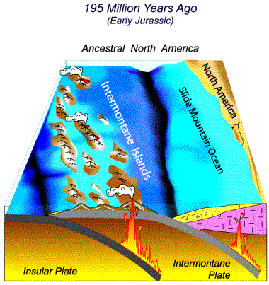
Volcanic Islands Approach the Northwest Coast Looking westward from Spokane or Pullman 195 million years ago, you would have had a sweeping view of endless ocean, or at least so it would have appeared. Some 800 to 1000 miles out to sea, however, changes loomed on the horizon. A giant island chain, 600 to 800 miles long, rode atop a small fragment of the Farallon Plate called the Intermontane Microplate. These islands were an active volcanic chain known as the Intermontane Volcanic Islands. “Intermontane” is a French word meaning “between the mountains.” The rocks of the Intermontane Islands eventually ended up between the Rocky Mountains and the Cascade Mountains, thereby earning their name. 195 million years ago, the Intermontane Islands were distant, exotic lands on a collision course with the Pacific Northwest. |
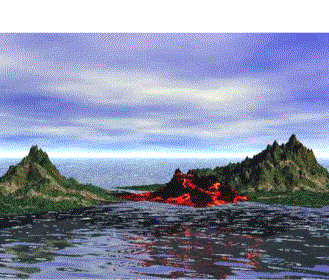
Artist’s conception of the Intermontane Volcanic Islands approaching the distant margin of Washington 195 million years ago. (Image: C. L. Townsend) |
|
Today, rocks of the Intermontane Islands form a “superterrane” -- an enormous block of crust composed of smaller terranes, all sharing a distinctive geologic history and bounded by faults. The Intermontane superterrane is built of four smaller terranes, each named after locations in British Columbia. These include the Stikine, Cache Creek, Slide Mountain, and Quesnel (“ken-el”) terranes. These terranes originated as either volcanic islands or slabs of seafloor. The Intermontane terranes make up thousands of square miles in a large plateau region in British Columbia and extend all the way to the Yukon Territory. Along the southern end of the Intermontane Belt, the Quesnel Terrane makes up most of the Okanogan region of north-Central Washington, extending as far west as the Methow Valley. The Intermontane Belt certainly extends further south in Washington, but just how far is anyone’s guess. Younger volcanic rocks of the Columbia Plateau completely bury the Intermontane belt to the south. |
|
Twin Subduction Zones
The Intermontane Islands had been accumulating as a volcanic chain somewhere out in the Pacific Ocean since Triassic time, beginning around 245 million years ago. The volcanism records yet another subduction zone. Beneath the far edge of the Intermontane microplate, another plate called the Insular microplate was sinking. This arrangement with two parallel subduction zones is unusual. The modern Philippine Islands are one of the few places on Earth where twin subduction zones exist today. Geologists call the ocean between the Intermontane islands and North America the “Slide Mountain Ocean.” The name comes from the Slide Mountain Terrane, a region made of rocks from the floor of the ancient ocean. |
The approach of the Intermontane Volcanic Islands to the ancient margin of the Pacific Northwest. The Farallon Plate has fragmented into two smaller “microplates,” each with their own subduction zone. Molten rock from subduction of the Intermontane Plate intruded into the old rocks of North America. At the same time, the Insular Plate fed molten rock to build the Intermontane Islands offshore. When the islands finally collided with the continent, the Intermontane subduction zone jammed and shut down entirely. |
|
The Intermontane Islands Collide Over early Jurassic time, the Intermontane Islands and the Pacific Northwest drew closer together as the continent moved west and the Intermontane Microplate subducted. On the continent, subduction supported a new volcanic arc that again intruding granite-type rocks into the ancient continental sediments. Eventually, about 180 million years ago in Mid-Jurassic time, the last of the microplate subducted, and the Intermontane Islands collided with the Pacific Northwest. The Intermontane Islands were simply too big to sink beneath the continent. The subduction zone of the Intermontane Plate shut down, ending the volcanic arc. As the Intermontane Belt accreted to the edge of the continent, the subduction zone of the Insular Plate became the active subduction zone along the edge of the continent. |
|
Molten Rock Intrudes through the Continent: The Omineca Arc Although it only happed at a couple of inches a year, the collision of the Intermontane Islands with the continent was an Earth-wrenching affair. Along the former edge of the continent, the ancient sedimentary rocks and the younger granite-type igneous rocks were crumpled and folded, raising a new mountain range in what geologists now call the “Kootenay Fold Belt” in far eastern Washington and British Columbia. |
|
|
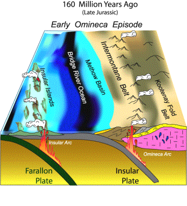
Within the Intermontane Belt, rocks of the old volcanic islands folded, crumpled and stacked against each other and thrust over the edge of the continent. They accumulated as a thick welt along the newly accreted edge of the continent. In the diagram at right, the Intermontane Belt (in brown) and the floor of the Slide Mountain Ocean (in gray) are pushed up onto the ancient margin of North America. The new coastline and shelf was now located along the eastern edge of what is today the Methow Valley. The Insular Plate subduction had fed molten rock to the volcanic arc of the Intermontane Islands before collision with the continent. Now, the Insular Plate served a new role: It created a new continental volcanic arc called the Omineca Arc along the new margin of North America. Molten rock ascending from the Omineca Arc effectively welded the Intermontane Islands to the ancestral coast of North America. |
By 160 million years ago, the original continental margin was crushed by the Intermontane Islands (shown in brown) to form the Kootenay Fold Belt. The Insular Plate took over as the active subduction zone along the margin of the continent. As it did, a new continental arc –the Omineca Arc -- sent molten plutons of granite rising into the crust to “weld” the Intermontane Belt to the continent. Sediment eroded from the Omineca Arc accumulated along the eastern Methow Shelf (shown in yellow). Further offshore, yet another chain of volcanic islands slowly approached the Pacific Northwest. |
|||
|
A New Continental Shelf
Adjacent to the new edge of the continent, a chain of volcanoes rose through the old Intermontane Belt, fed by molten rock of the Omineca Arc. Rivers draining the volcanic highlands carried volcanic mud, silt, sand and other debris to the new coastline. These sediments dispersed largely by deltas along the Methow continental shelf. They outcrop today in layers of sedimentary rock in the Methow Valley. One hundred and sixty million years ago, this was oceanfront property for the local dinosaur population. |
|
||||
|
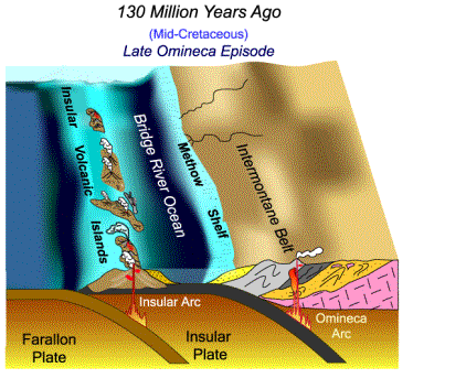
Approach of the Insular Volcanic Islands The Omineca Arc supported a chain of continental volcanoes in Washington and British Columbia off and on for some 60 million years. Over this time, sedimentary rocks in the Methow Valley record a continuous pattern of deposition from volcanic sources to the east. A startling change in this depositional pattern happened about 130 million years ago in mid-Cretaceous time. For the first time in 60 million years, sand eroded from new offshore lands to the west started appearing within the Methow Basin. These sands marks the first appearance of the Insular Volcanic Islands –- the next major volcanic island group to be added to the edge of the continent. |
The approach of the Insular Volcanic Islands is recorded by sediment deposited along the margins of the Bridge River Ocean. For 60 million years, sand eroded from eastern highlands in the Omineca Arc. About 130 million years ago, sediment eroded from new lands to the west was deposited (shown above by the yellow sand patterns). These sediment derived from the west are the first evidence of the approach of the Insular Volcanic Islands. |
|
As the Insular Volcanic Islands approached the Pacific Northwest, Washington moved into the next chapter of its geologic history, the Coast Range Episode. |
Continue to:
Return to:
§ The Restless Earth: A Geologic Primer
§ Dance of the Giant Continents: The Early History of Washington