Dance of the Giant Continents:
Washington’s Earliest History
|
Earth of the distant past was a very different planet than the one we know today. If you could travel through time to arrive at the Earth of a billion years ago, you would have a hard time navigating. A strange giant continent and a single planetary ocean would replace the familiar continents and oceans of today’s world. Yet, this is where the geologic history of Washington and the Pacific Northwest began -- on a giant continent of a billion years ago. |
Assembling the Giant Continent Rodinia
|
About 1.2 billion years ago, fragments of continental crust, pushed together by plate tectonic motion, began to assemble a giant continent. Geologists affectionately use the term “Rodinia,” a Russian word meaning “homeland,” for this giant continent of so long ago. Though the exact size and configuration of Rodinia are not known, rocks of ancestral North America, often called “Laurentia,” very likely formed the core of the giant continent. |
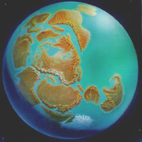
Artist’s conception of the supercontinent Rodinia as it began to fragment 750 million years ago. The future North America lies in the center of the surrounding lands. The breakup of this giant continent was the beginning of Pacific Northwest geologic history. Original painting by Tomo Narashima. |
|
The continent of Rodinia was the dominant landmass of the Earth for at least 350 million years. The configuration of the lands of Rodinia is a matter of considerable debate. The east coast of present North America was probably adjacent to western South America. The west coast of North America lay next to what is today Australia and Antarctica. There are several competing ideas for the distribution of land in the giant continent, and more will surely follow. Life in a Hostile World Rodinia was a stark and hostile land throughout its history. Much of what would become western North America was a vast floodplain, accumulating thick sequences of sand and silt. Life by this time had barely progressed beyond single-celled algae, so the land was completely devoid of plants. Most of the landscape was probably a rusty-red color.
A distinctive group of very ancient sedimentary rocks accumulated in a giant basin over part of what is now Alberta, British Columbia, Montana, Idaho and Washington between 700 million and 1.5 billion years ago. Geologists have named these rocks the “Belt Supergroup” after a small town in Montana. The Belt rocks are multicolored sandstone, siltstone and limestone noted for their beautiful preservation of sedimentary features such as mud cracks, ripple marks and abundant “stromatolites” –cabbage shaped fossils left by the action of cyanobacteria (blue-green algae). In Washington, the Belt rocks are exposed extensively in the eastern Okanogan Highlands. The Belt Group also makes up most of the spectacular mountains in Glacier National Park in Montana. The Belt rocks are remarkably thick. They accumulated to perhaps 50,000 feet near the Washington-Idaho line, and thin eastward toward central Montana. The rupture that split Rodinia abruptly truncated the basin in which the Belt sediments accumulated. The missing western margin of the Belt basin is now thought to be part of either Australia or Asia. |
The Breakup of Rodinia
|
The great supercontinent of Rodinia dominated the Earth for some 350 million years, a long time by any measure. But, not even supercontinents last forever. In the end, Rodinia fell victim to the Earth’s internal heat. A slow buildup of heat beneath Rodinia caused the old continent's crust to dome, stretch and weaken. Eventually, the entire continent ruptured. Violent spreading centers developed underneath the continent and began to slowly tear Rodinia apart. |
|
One fine day some 750 million years ago, the end of Rodinia began in what is now east-central Washington. The giant continent began to rupture along a line now running roughly north to south. At just a couple of inches a year it was a slow process, but over geologic time the increments started to add up. In ten million years, perhaps, the waters of the ocean flowed into the new rift valley. The original rift valley that split Rodinia was probably not unlike the modern rift between Saudi Arabia and Northeast Africa. |
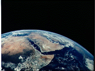
The Red Sea is a modern rift separating the Arabian Peninsula from northeastern Africa. The breakup of the supercontinent Rodinia probably began by a similar rift running near the present Washington-Idaho border. (Image: NASA) |
|
As the rift continued to grow, it eventually went on to form a vast ocean basin called the “Panthalassic Ocean,” a Greek word for “all the seas.” The Panthalassic Ocean separated the Americas, Siberia and Scandinavia from Antarctica, Australia, and the rest of the eastern hemisphere. The new coastline of ancestral North America now ran through what is today eastern Washington, not too far east of modern-day Pullman -- confirming the long-standing suspicion that Pullman was always a stone’s throw from the end of the world. |
|
The Early Coast of the Pacific Northwest (750-200 million years ago) As the great rift separated what is now Eastern Washington from Antarctica, Australia and northern China, it did so by pushing both halves of the supercontinent away from each other. As Rodinia split, the Panthalassic Ocean became ever wider. Undoubtedly, a mid-ocean spreading center lie along its axis creating new oceanic crust on the floor of the young ocean. |
. 
|
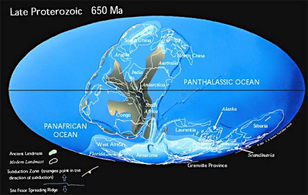
A reconstruction of the supercontinent Rodinia 100 million years after breaking apart. Note the position of Alaska and the western margin of North America (labeled “Laurentia”). The giant continent split along the eastern margin of what is today Washington State. The future Pacific Northwest was a tectonically quiet, passive continental margin. (Image: Christopher Scotese, Paleomap Project) |
|
Along Rodinia’s Quiet Margin The broken edge of Rodinia through eastern Washington was a quiet, passive continental margin, far removed from the violent tectonics we associate with the Pacific Northwest today. For four hundred million years, the original coast of Washington would enjoy this tectonically quiescent setting.
An Explosion of Life As the Pacific Northwest comfortably passed through the Paleozoic Era, it witnessed a veritable explosion of life. Off its shores, most of the major groups of animals first appear in the fossil record in the Cambrian Period some 540 million years ago. The first fish appeared in the Ordovician Period, perhaps 500 million years ago. The first plants invaded the land in the Silurian Period, about 420 million years ago. The earliest amphibians showed up in the Devonian Period, perhaps 370 million years ago, while the first true reptiles arrived on the scene in the Carboniferous Period about 320 million years ago. Rocks representing each of these time periods are preserved in Eastern Washington along the ancient marine shelf of Rodinia. A New Subduction Zone Somewhere around the Devonian Period some 370 million years ago, a major change occurred along the continental margin. The oceanic plate, previously fixed to the continental margin, plunged underneath the continent along a new subduction zone. This ended a 400 million year history as a passive continental margin. Along the coast in Eastern Washington and British Columbia, that newly-subducting plate gave rise to a volcanic arc which developed inland, intruding granite-type plutons into continental sediments which had been accumulating for over a billion years. This volcanic arc appears to have lasted from about 350 to 280 million years ago. The Supercontinent Pangaea
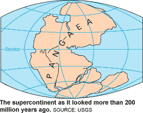
Pangaea persisted over much of the Permian and Triassic periods, a span of some 100 million years. Over this period, the western shoreline curved through western Idaho. Sediment – mud, silt, sand and calcium carbonate -- accumulated in thick layers beneath shallow seas along the continental shelf of Eastern Washington. The construction Pangaea left much of present North America as a windswept desert. Coupled with the widespread extinction of life on both land and water, it presented a pretty bleak picture. Conditions improved measurably in Triassic Period, and life recovering to a significant degree. From the survivors of the Permian-Triassic extinction, life gave rise to the first true Dinosaurs and the earliest mammals. On the ancient supercontinent of Pangaea, things were finally starting to look better. All good things come to an end. This quiet and comfortable arrangement in the Pacific Northwest ended a little more than 200 million years ago, as Pangaea began to break apart. The Breakup of Pangaea Like its predecessor Rodinia, the giant continent of Pangaea would also fall victim to the Earth’s internal heat. About 205 million years ago, Pangaea began to rupture to form the Atlantic Ocean. The breakup began as a rift between the modern western and eastern hemispheres. The rift evolved into a spreading center that literally pushed the two hemispheres apart.
|
|
|
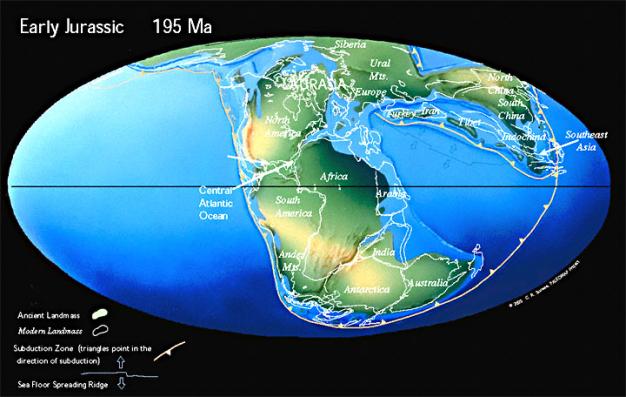
Early stage in the breakup of Pangaea 195 million years ago. The suture between North and South America and Africa is just beginning to rupture, ultimately to open the Atlantic Ocean. Note that much of the Pacific Northwest is a continental shelf under shallow water. Offshore, a subduction zone has formed along the margin of the Pacific Northwest. As North America was forced westward by the spreading of the Atlantic Ocean, Washington and the Pacific Northwest became a tectonically active continental margin. (Image: Christopher Scotese, Paleomap Project) |
|
|
With the breakup of Pangaea, North America was forced to drift westward at the same rate the Atlantic Ocean was spreading. This westward drift had an enormous affect on the Pacific Northwest. After being a quiet, passive continental margin for most of its history, the days of quiescence were over. New tectonic activity began to affect the edge of the continent as the floor of the Pacific Ocean basin floundered against the western continental margin. The breakup of Pangaea ushered Washington into a new era of geologic history. Active subduction zones, volcanic islands and violent continental arcs characterized this new era. The next section, New Lands Along an Old Coast, describes the evolution of Washington and the Pacific Northwest over the last 200 million years as Pangaea broke apart. |
|
|
Continue:
§ New Lands along an Old Coast: Building the Pacific Northwest
Return:
§ Dance of the Giant Continents