Curriculum
Back to Background Material
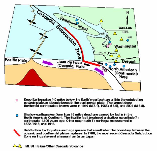
The Pacific Northwest
Three types of earthquakes occur in the Pacific Northwest: subduction, deep, and shallow (or surface). (Also described in Panel Text, pg. 3.) Interaction between the Juan de Fuca oceanic plate and the North America continental plate drives these faults. Because the Juan de Fuca is denser it slides under or subducts beneath North America. As it descends, the locking and unlocking of the two plate margins causes subduction quakes.
Subduction quakes are usually massive with ground breaking occurring along hundreds of kilometers of the coastline. S hallow or crustal earthquakes are less related to subduction. Geologists believe they are mostly due to shortening within the crust or top layer of North America.
Deep Quakes
The second location and most common source for large earthquakes in the PNW is the area where the descending Juan de Fuca plate reaches about 50 kilometers (30 miles) in depth directly beneath Puget Sound (see diagram on page 16). The 2001 Nisqually quake was a deep quake, as werel both big local earthquakes in 1949 and 1965. The largest quakes on this fault have a potential magnitude of 7.5. This type of quake produces virtually no aftershocks; none were recorded in 1949 or 1965 and only a few in 2001.
Cascadia
Geologists have labeled the area where Juan de Fuca begins to subduct the Cascadia subduction zone . This zone stretches over 965 kilometers (600 miles) from British Columbia to northern California and is the most extensive fault system in the Pacific Northwest area. It surfaces about 80 kilometers (50 miles) offshore along the Pacific coast. The last time it moved was on January 26, 1700. Geologists estimate that it was a magnitude 8.0 - 9.0 earthquake. It generated a tsunami that flooded villages in Japan. No one knows when Cascadia will move again but evidence appears to point to movement every few hundred years.
*Discovering and fleshing out the details of this most recent movement on the Cascadia subduction zone was one of the great scientific detective stories of the Pacific Northwest. In the mid-1980s, geologist Brian Atwater observed ghost forests-long-dead trees-standing stark along the coasts of Washington and Oregon. He knew that similar stands of trees in Alaska had been killed after the Prince William Sound earthquake of 1964 when a forest dropped several feet below sea level, allowing tidewater to rush in and drown the trees. Over time, tidal mud accumulated and the area became a salt marsh and then a coastal meadow. But the dead trees still stood.
Atwater wondered whether the Washington and Oregon ghost forests were like Alaska's drowned forests. He knew that great subduction zone earthquakes usually produce tsunamis-massive waves that travel with jet-like speed across the ocean. Near shore, tsunamis reach towering heights and surge far inland. When Atwater looked at the ghost forests, he found distinctive layers of sand over the soil.
Carbon dating showed that the Washington and Oregon ghost forests had died between the years 1680 and 1720. Atwater reasoned that a massive earthquake in the Northwest could have killed the ghost trees. He also knew that such a large quake would generate tsunamis. These waves would strike all around the Pacific. So he looked to Japan for evidence, because Japan has some of the oldest written records of any country along the Pacific Rim.
Japanese researchers found records of only one large tsunami between 1680 and 1720. From maps and manuscripts, they learned that the tsunami had flooded several Japanese villages, including one called Otsuchi. If a Northwest earthquake had caused this tsunami, they calculated, the event would have taken place on the evening of January 26, 1700. (Described in greater detail in Panel text, pgs. 5-6)
Shallow
The third type of quakes occur within 24 kilometers (15 miles) of the surface. The best known and most recently discovered shallow source for Big Ones in the PNW is known as the Seattle Fault. (Also described in Panel text, pg. 7) Geologists now have evidence that the northern edge of the fault zone basically runs along I-90 from Issaquah to Safeco Field, continues west through Alki Point, Restoration Point on Bainbridge, and Bremerton before terminating at Hood Canal. This 72-kilometer long, 4- to 6.5-kilometer-wide (45-mile long, 2.5- to 4-mile-wide), east-west series of cracks has the greatest potential for significant earthquake damage in Seattle.
Unlike the February 28, 2001 earthquake, which occurred 48 kilometers (30 miles) underground, movement on the Seattle Fault would occur within 24 kilometers (15 miles) of the surface and has the potential to rupture the ground. This happened most recently about 1,100 years ago, when the fault, in one dramatic movement, propelled rock up to 7 meters (20 feet) out of Puget Sound, triggering rock avalanches in the Olympics, underwater landslides in Lake Washington, and a tsunami that inundated West Point at Discovery Park in Seattle.
The recent squarm of earthquakes in Spokane in 2001 were shallow quakes. More than 75 have been recorded since May 24, and dozens more could not be measured because of a lack of seismographs. The strongest quake in the current swarm occurred on Nov. 11, a magnitude 4 temblor that was followed by quakes measuring 3.1 and 3.3 over the next few hours. (Also described in Panel text, pg. 7)
The 1872 Lake Chelan quake also was shallow. Geologists have neither conclusive evidence to its cause nor scientific accounts of what happened. All information is from local reports.
Three large faults also run under Portland. The best known is thePortland Hills Fault, a 48-kilometer- (30-mile) long fault -- actually a complex "fault zone" containing multiple fractures - that runs in a northwest-southeast direction through Portland. (For additional information, see Airborne Hunt for Faults in the Portland-Vancouver Area, in reference section.)
|
Deep |
Shallow |
Subduction Zone |
Largest Known |
7.1
1949, Olympia |
7.4
1872, North Cascades
900 AD, Seattle |
9.0
1700, Coast of WA, OR, CA, and BC |
Largest Possible |
7.5 |
less than 8 |
9+ |
Where is the
Rupture? |
20-45 miles deep, beneath Puget lowland, Willamette Valley, Strait of Georgia |
Seattle, Portland,
North Cascades,
Vancouver Island,
other unidentified locations |
Offshore, on a shallow-dipping fault that runs from Vancouver Island to Northern California |
How deep is the
Rupture? |
At a depth of 30-40 miles. |
Less than 15 miles deep; may break the surface. |
From 20 miles depth to the surface |
How Often? |
Five magntude 6 earthquakes, plus one magnitude 7 since 1900 |
Four magnitude 7 or greater known in the last 1,100 years; including two this century on Vancouver Island |
Every 400-600 years; intervals between events are irregular. The most recent was in 1700. |
Why? |
Gravitational pull and phase changes within subducting oceanic Plate |
Crustal Stresses |
Plate convergence at locked interface between Juan de Fuca and North American Plates |
Precursors? |
None expected |
Unclear |
Probable |
Aftershocks? |
Damaging aftershocks unlikely, none recorded in1949 or 1965. In 2001, aftershocks were small and few |
Many expected, magnitudes to 6.5 |
Many expected, magnitudes to 7.5 |
Shaking Duration?
(on rock) |
15-30 seconds of strong shaking* |
20-60 seconds of strong shaking* |
1-3 minutes of strong shaking* for a magnitude 8 |
Shaking Strength?
(on rock) |
0.2-0.35 g ** |
Greater than 0.5 g ** |
0.3 g in urban areas**
Greater than 0.5 g near coast**
Longer period shaking than other sources |
Tsunami? |
Not from fault motion, but landslides could trigger local tsunamis. |
Possible in Puget Sound, if the rupture is underwater and displaces the bottom of the Sound, or if landslides trigger local tsunamis. |
Yes, near coast |
Liquefaction? |
Yes |
Yes |
Yes |
Landslides? |
Yes |
Yes |
Yes |
Modified from http://www.ess.washington.edu/SEIS/PNSN/CascadiaEQs.pdf
Acceleration values are in reference to the acceleration due to Earth's gravity, "g"
* Durations of strong shaking on rock; longer durations are expected on soft ground
** Accelerations on rock; larger accelerations are expected on soft ground
From: http://www.ess.washington.edu/SEIS/PNSN/INFO_GENERAL/eqhazards.html |