Curriculum
Back to Background Material
What are Earthquakes?
An earthquake is the sudden shift of rock along a fracture in the Earth. The shift releases energy, which travels in waves to the surface and makes the ground shake. Earthquakes occur everyday across the planet and can originate at the surface or as deep as 650 kilometers (400 miles). Most occur less than 100 kilometers (62 miles) below the surface. This point or plane of rupture is known as the focus or hypocenter. The epicenter is the place on the surface of the earth immediately above the focus. This is the place from which we obtain our earthquake measurements.
From: http://earthquake.usgs.gov/4kids/image_glossary/epicenter.html
Many earthquakes are so small that we cannot feel them. Some, on the other hand, have caused great destruction and have killed hundreds of thousands of people. Over one million earthquakes may occur each year. Most earthquakes last only seconds, but some extremely large quakes may last minutes.
How strong an earthquake feels to an observer depends on distance from the epicenter. It also depends on the regional geology, whether one is in a building or not and what type of building one is in, and the observer. Earthquakes are measured in both magnitude, defined as a measure of the strength of an earthquake or energy released by it, and intensity, or the effect of an earthquake on the Earth's surface. (For more information see Magnitude and Intensity section)
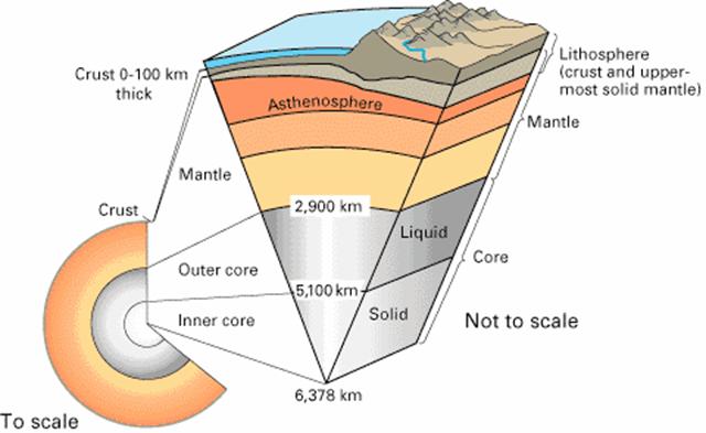
A Cross Section of Earth
People have pondered the origin of earthquakes for thousands of years with many fanciful ideas. Scientists have only recently, within the past 100 years, begun to understand the mechanisms behind earthquakes. The key to understanding earthquakes was figuring out that the planet is layered, like a giant hard boiled egg, with three main layers: crust, mantle, and core. (Also described in Panel Text, pg. 2) The mantle constitutes 82% of the volume of the Earth's sphere. In our egg model it is similar to the white of the egg. The outside thin layer similar to the egg's shell is the crust. The center of the earth's core, similar to the egg yolk, is composed of very dense and very hot metals.
At the center of the Earth lies the core, which is nearly twice as dense as the mantle because its composition is metallic (iron-nickel alloy) rather than stony. Unlike the yolk of an egg, however, the Earth's core is actually made up of two distinct parts: a 2,200-kilometer (1,400-mile) thick liquid outer core and a 1,250-kilometer (775-mile) thick solid inner core.
Below the crust is the mantle, a dense, hot layer of heat-softened rock approximately 2,900 kilometers (1,800 miles) thick. Heat within the mantle creates giant convection currents, like the blobs in a lava lamp, except with movement on a geologic timescale. Hot mantle material slowly moves up and cools near the surface. The cold, dense material drops down. These currents move the plates above. As a comparison, the mantle might be thought of as the white of a boiled egg.
Drawing from: http://earthquake.usgs.gov/faq/plates.html#4
The crust, the outermost layer, is rigid and very thin compared with the other two. It ranges in thickness from about 5 kilometers (3 miles), beneath the oceans, to up to 65 kilometers (40 miles), under mountains on continents. Average continental thickness is about 16 kilometers (10 miles).
Plate tectonics
The theory of plate tectonics states that the plates that make up the Earth's outermost layer are moving very slowly relative to one another as they ride atop hotter, mobile material . Plate tectonics has only been developed and widely accepted over the past 40 years or so. The first inkling of plate tectonics came in 1911, when a 31-year-old German meteorologist named Alfred Wegener proposed the idea that continents moved. He called his theory Continental Drift and based his evidence on fossil and rock data and how continents of the southern hemisphere, such as Africa, Australia, and South America fit together.
In the 1960s, scientists discovered that the material (crust) was slowly being added to the ocean floor. They then hypothesized that since the planet was not growing bigger that some ocean floor had to be destroyed, to compensate for the new material. This led to the idea that continents moved with the sea floor. They also recognized that there must be margins where new material was produced and consumed and the Theory of Plate Tectonics was born. As more and more data has accumulated, plate tectonics has become the best way to explain most geologic processes. It is one of the great scientific discoveries of all time.
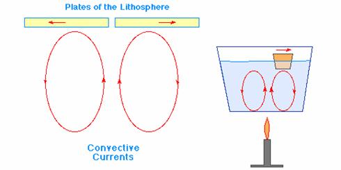
Scientists, now know that convection currents within the mantle transport the plates. Heat that remains from the Big Bang at the formation of the universe combined with heat produced from radioactive decay produce the convection currents. As the heat rises, it spreads away from a central point and carries the plates with it. This forces the plates to interact. ( Also described in Panel text, pg 2. ) When two plates interact they do not slide by or atop each other in a smooth motion. Instead, they lock together, like two pieces of velcro, which builds up energy. When the lock breaks, again like Velcro, energy is released as earthquake waves that spread outward in all directions.
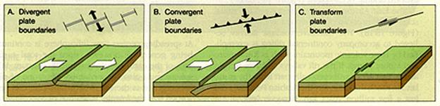
Plate boundaries
Divergent boundaries - They occur at spreading centers where plates are moving away from each other and new crust is actively being formed by magma rising from the mantle. A divergent boundary resembles giant conveyor belts moving in the opposite direction. The mid-Atlantic ridge, which runs like a zipper down the Atlantic Ocean, is probably the best known spreading center. Over the past 100 to 200 million years, it has spread at a rate of about one inch per year, and pushed Europe, Africa, and North and South America to their present positions.
The Red Sea is another spreading center where the Arabian Plate is pulling apart from the African Plate, generating many earthquakes in the Middle East and Africa.
Convergent boundaries - Two plates crashing together is known as a convergent boundary. This can occur between oceanic margin and continental margin and two continental margins. The best known in the Pacific Northwest is where the Juan de Fuca ocean plate slides or subducts under North America, which has led to the formation of our mountain ranges. Subduction is responsible for most of the major earthquakes along what geologists call the Ring of Fire, a zone of earthquakes that rings the entire Pacific Ocean.
Oceanic plate, created at spreading centers, subducts under continental crust because of its greater density. Magma rising at spreading centers is rich in iron and manganese, while silica and aluminum, both light elements, dominate in continental crust. As the plates collide the heavier oceanic crust dives deep under the continent.
A continent-continent collision created the Himalayas roughly 50 million years ago when India rammed into Asia. The land crumpled at their boundary, like two cars colliding. The two plates are still moving toward each other, slowly pushing the Himalayas higher. Most of this growth has occurred during the past 10 million years.
Transform Boundary - The zone between two plates sliding horizontally past one another is called a transform-fault boundary, or simply a transform boundary. Most transform faults are found on the ocean floor. They commonly offset the active spreading ridges, producing zig-zag plate margins, and are generally defined by shallow earthquakes. The best known, however, occurs on land, the San Andreas fault zone in California.
The San Andreas fault zone, which is about 1300 kilometers (800 miles) long and in places tens of miles wide, slices through two thirds of the length of California. Along it, the Pacific Plate has been grinding horizontally past the North American Plate for 25 million years, at an average rate of about 5 cm/yr (2 in/yr). Land on the west side of the fault zone (on the Pacific Plate) is moving in a northwesterly direction relative to the land on the east side of the fault zone (on the North American Plate).
|