Researching the Risks
In addition to solving the Big One mystery, lots
of research is going on right in our own backyard.
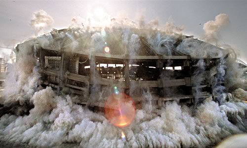 |
Seattles Kingdome imploding.
When Seattles Kingdome was scheduled for implosion
(the opposite of explosion), one study placed seismographs
in backyards and schools around the Seattle area. The results
are helping to create a detailed picture of which neighborhoods
are most vulnerable to earthquake shaking.
|
Uncovering the Seattle Fault
|
The discovery that a Big One really had happened in the Pacific
Northwest prompted new interest in our regions geology.
Within a few years, reseachers found evidence of another great
earthquake, one that took place 1,100 years agoright
under Seattle.
Unlike the big subduction zone earthquake in 1700, this one
was centered on a fault that lies close to the surface. Thats
significant. Movement along a shallow fault can cause very
intense shaking, and the Seattle Fault runs through one of
the most heavily populated parts of Washington. There are
shallow faults beneath Tacoma and Whidbey Island as well.
The information we get from studying the Seattle Fault helps
predict earthquakes throughout the Pacific Northwest.
In order to better understand the risks to communities, scientists
today are making use of ingenious new approaches to map the
geologic structures beneath Puget Sound.
|
 |
|
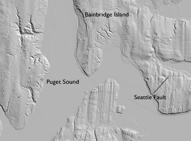
LIDAR (Light Distance and
Ranging) technology uses airplane-flown lasers to reveal
surface features hidden by buildings and vegetation. This
map traces part of the Seattle Fault.
|
Quakes in Eastern Washington
 |
Although
the risk is greater west of the Cascades, the Columbia Plateau
also is geologically active. The ground shaking that took place
in Spokane in the summer of 2001 was a reminder that Eastern
Washington has earthquakes, too. In fact, a very large earthquake
occurred near the southern tip of Lake Chelan in 1872, and a
moderate earthquake damaged Walla Walla in 1936.
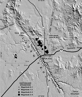
Just a few months after the 2001 Nisqually earthquake, Spokane
experienced a series of small, shallow, closely spaced earthquakes
that geologists call a swarm. More than 80 small
earthquakes were recorded by the end of 2001. The largest quake
of the swarm was a magnitude 3.9. Another notable swarm began
in November of 1987 near Othello, Washington. That series of
200 quakes took place over nearly a year. |
Aerial
image of Latah Creek in Eastern Washington
Straight lines are rare in nature, and may be signs of an underlying
fault. Some geologists believe a fault beneath Latah Creek is
responsible for the recent earthquake swarm in Spokane. |
|
Portland's Shallow Faults
It can be difficult to find surface faults in the tree-covered
Northwest. Today, hidden shallow faults can be seen
by a variety of new technologies, including those that use the natural
magnetism of rocks. In the Portland-Vancouver area, studies revealed
the almost-straight line of the Portland Hills fault zone. If this
fault becomes active, it poses significant seismic hazard to the
communities near Portland, Oregon, and Vancouver, Washington.
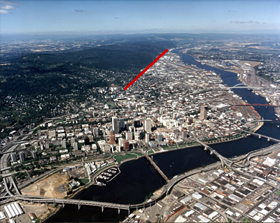 |
Red line shows the Portland Hills fault zone.
|
|