Maps & Images
-
Intro
Map/Image Credit 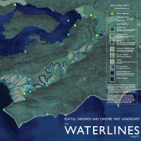
The Waterlines Project Map
Production by Amir Sheikh in collaboration with Brian Collins, Don Fels, Peter Lape, Joyce LeCompte, Coll Thrush, Cynthia Updegrave, and David Williams. Additional contributions and reviews provided by Brian Atwater, Brian Boram, Steve Denton, Jolene Hass, Warren King George, Lorraine McConaghy, Jess Milhausen, Megon Noble, Laura Phillips, Aaron Raymond, and Ken Yokum. Map designed by Michael Lewis and Jordan Monez of About Nature.
This project was supported, in part, by an award from 4Culture.
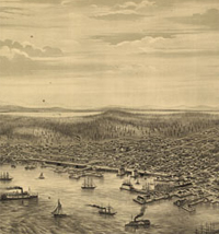
Bird's eye view of the city of Seattle, Puget Sound, Washington Territory, 1878.
A.L. Bancroft & Co., lithographers
Drawn by E.S. Glover
Library of Congress Geography and Map Division, Washington, D.C. -
Puget Sound
Map/Image Credit 
20,000 Years in Puget Sound
From glaciers to volcanoes to earthquakes, witness the processes that have shaped the Puget Sound landscape. (YouTube)
Production by Amir Sheikh. Model developed by Ralph Haugerud with assistance from Harvey Greenberg. Edit and titles by Britta Johnson. Content assistance by Brian Atwater. Courtesy of WSDOT. Created for Milepost 31.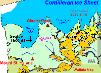
Pacific Northwest and the "Missoula Floods"
Topinka, USGS/Cascades Volcano Observatory, 2002;
Modified from: Waitt, 1985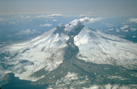
Mt. St. Helens, 1982 Eruption
Photograph taken on March 21, 1982, by Tom Casadevall
USGS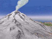
Osceola Mudflow, Mt. Rainier, Washington
Animation by Jose Vigil
USGS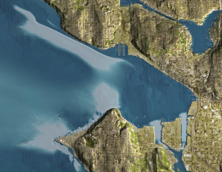
Seattle Fault Earthquake, Seattle Inundation
Animation courtesy of the National Oceanic and Atmospheric Administration (NOAA) Center for Tsunami Research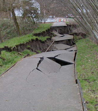
Earthquake Damage Pictures: Capitol Lake, Olympia
From the Nisqually Earthquake Information Clearinghouse
Photo by Steve Kramer
2001
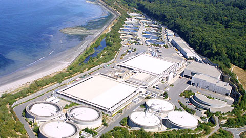
West Point Sewage Treatment Plant
Photo courtesy of King County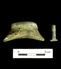
Labrets from the West Point site
Photo courtesy of King County
Button style steatite labret, Burke Museum cat.# B1-1277.01
T-shaped stone labret, Burke Museum cat.# B2-1161.02 -
Duwamish River
Map/Image Credit 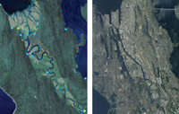
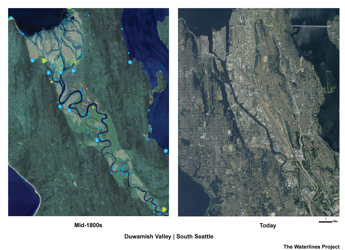
The Duwamish Valley/South Seattle mid-1800s & today
Detail of The Waterlines Project Map
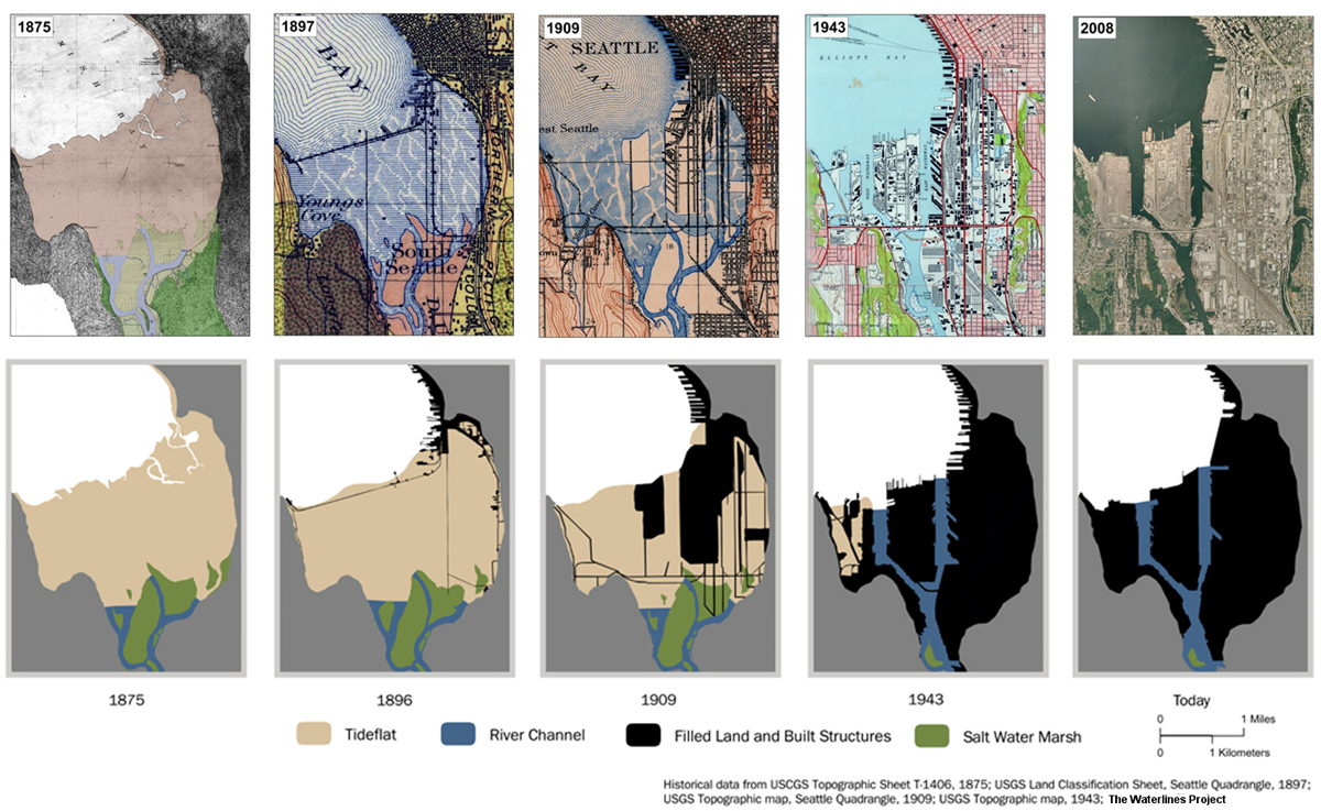
The Transformation of the Duwamish Estuary
Historical data from USCGS Topographic Sheet T-1406, 1875; USGS Land Classification Sheet, Seattle Quadrangle, 1897; USGS Topographic map, Seattle Quadrangle, 1909; USGS Topographic map, 1943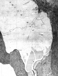
United States Coast & Geodetic Survey Topographic Sheet T-1406; Duwamish Bay, (part of) Washington Territory, Scale: 1:10,000;
Surveyor: Jas. S. Lawson
1875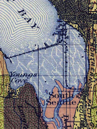
USGS Land Classification Sheet, Washington, Seattle quadrangle. 1:125,000
1897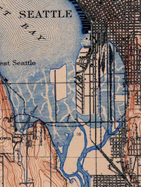
USGS Topographic Map; Seattle quadrangle 1:125,000
1906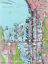
USGS Topographic Map; Seattle quadrangle 1:24,000
1943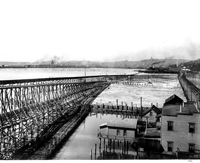
Elliott Bay in 1901 before the tidelands were filled, showing South Canal trestle and Grant St. Bridge
Photo by Curtis, Asahel, 1874-1941
1901
Negative number: A. Curtis 01771
Courtesy of University of Washington Libraries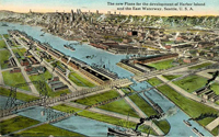
Bird's-eye view of Harbor Island and the East Waterway, Seattle, ca. 1915
Photographer unknown
ca. 1915
Negative number: UW5987
Courtesy of University of Washington Libraries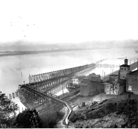
South Canal trestle; filling tideflats near Bay View Brewery, Seattle, 1901
Photo by Curtis, Asahel, 1874-1941
1901
Negative number: UW26754
Courtesy of University of Washington Libraries
Newly-filled land on West Duwamish Waterway, looking west, Seattle
Photo by Curtis, Asahel, 1874-1941
ca. 1904
Order number: CUR308
Courtesy of University of Washington Libraries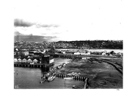
Panorama from Centennial Mill showing Seattle in 1902
Photo by Curtis, Asahel, 1874-1941
1902
Negative number: A. Curtis 00553
Courtesy of University of Washington Libraries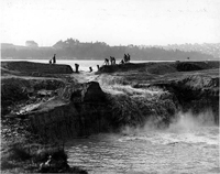
Cutting away the cofferdam at the Montlake Cut between Lake Washington and Lake Union
Photographer unknown
ca. 1899
Order number: WWDL0572
Courtesy of University of Washington Libraries
Building a dam on the Black River near Renton to divert the path of the Cedar River, ca. 1899
Photographer unknown
Possibly not before 1916
Negative number: UW 2382
Courtesy of University of Washington Libraries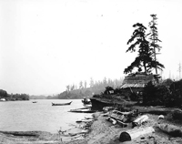
Salmon Bay Charlie's house at Shilshole with canoe anchored offshore, ca. 1905
Photo by Webster & Stevens
ca. 1905
Negative number: MOHAI 83.10.9,067
Courtesy of University of Washington Libraries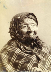
Angeline, daughter of Chief Seattle, ca. 1893
Photo by La Roche, Frank
ca. 1893
Negative number: NA895
Courtesy of University of Washington Libraries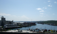
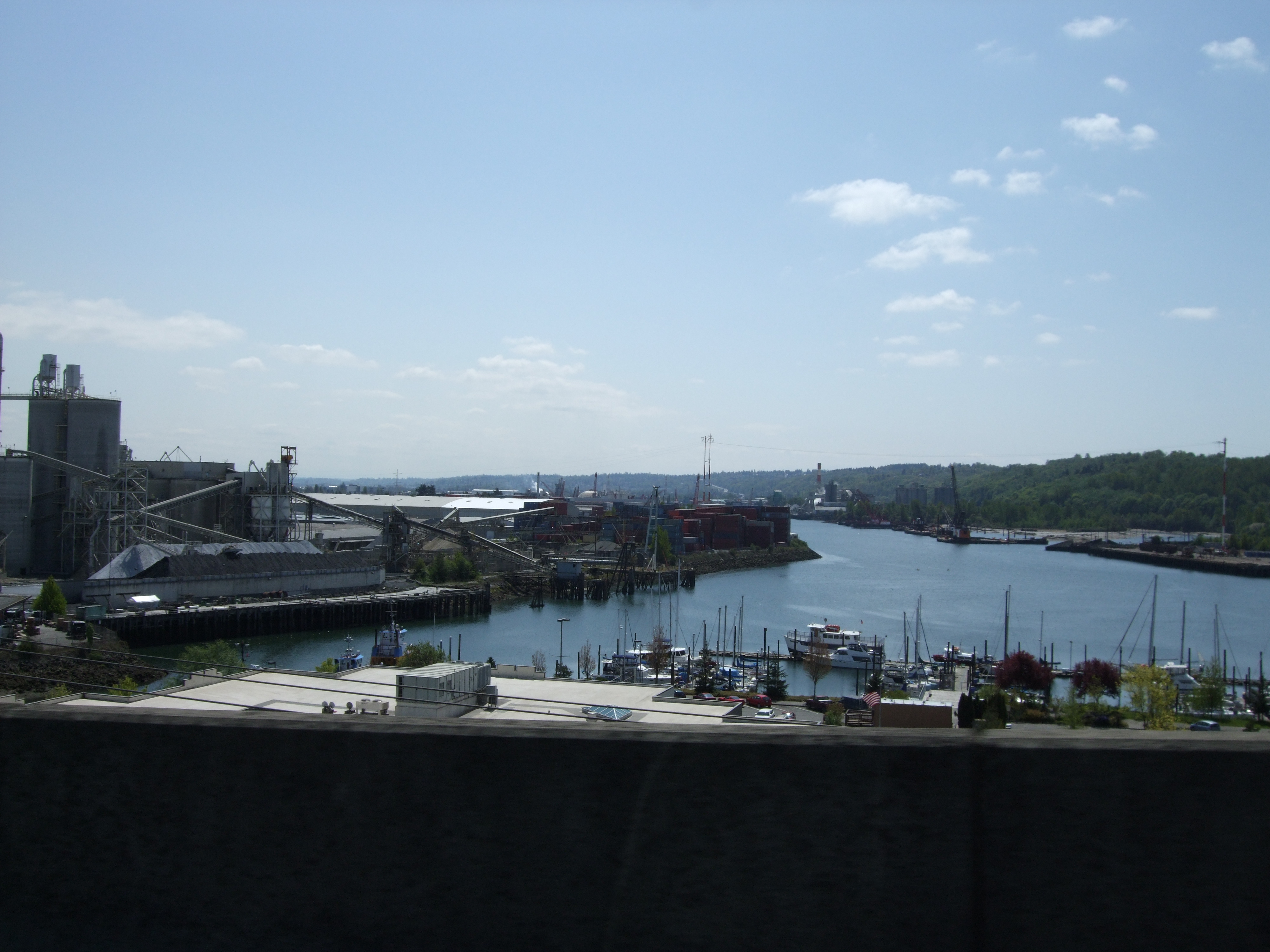
Duwamish River today
Photo © Cassy Jarvis
2008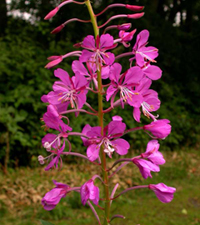
Native plant: Chamerion angustifolium
From the Burke Museum Herbarium/WTU Image Collection
Photo © Ben Legler
2004 -
Pioneer Square
Map/Image Credit 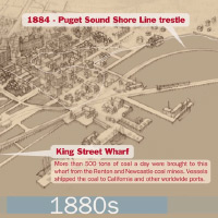
Djidjila'letch to Pioneer Square
From native village to metropolis, the Pioneer Square neighborhood of Seattle has undergone dramatic transformations. This animation provides a bird's eye glimpse at some of the social, economic, and landscape histories of the neighborhood through time. (YouTube)
Production by Amir Sheikh. Illustrations by Jessica Miller. Edit and animation by Britta Johnson. Courtesy of WSDOT. Created for Milepost 31.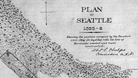
Plan of Seattle, 1855-6
ca. 1855
Courtesy of University of Washington Libraries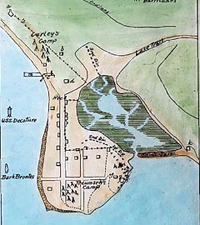
Plan of city during Battle of Seattle, 1856
1856
Courtesy of University of Washington Libraries
Image number: 2002.3.549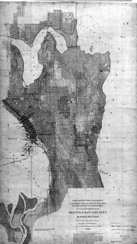
United States Coast & Geodetic Survey Topographic Sheet T-2421; Seattle Bay and City, City from and head of bay, Wash. Ter.; Scale: 1:10,000;
Surveyor: J.J. Gilbert
1899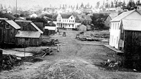
Seattle, from Occidental Avenue and Washington Street, looking north, in the 1870s
Prosch Seattle Views Album, Vol. 2
Courtesy of University of Washington Libraries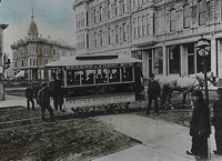
First streetcar, Seattle, September 1884
Photo by Peiser, Theodore E.
1884
Image number: 2002.3.439
Courtesy of University of Washington Libraries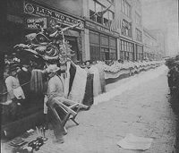
Chinese dragon parade on Third Avenue, Seattle, ca. 1900
Photographer unknown
ca. 1900
Image number: 1992.025.007
Courtesy of University of Washington Libraries
Celebration honoring volunteers of the First Washington Volunteer Infantry Regiment, Pioneer Square, 1899
Photo by Wilse, Anders Beer
1899
Negative number: Wilse 261
Courtesy of University of Washington Libraries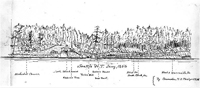
Seattle, Drawing, January 1856
Artist unknown
Negative number: UW 1682
Courtesy of University of Washington Libraries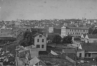
First Avenue South and Main Street, looking northeast, Seattle, 1883
Photo by Peterson & Brothers
1883
Image number: SHS3573
Courtesy of University of Washington Libraries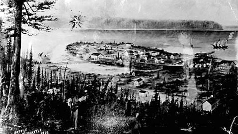
Battle of Seattle, 1856
From a sketch or painting by Clarence Hanford
Courtesy of University of Washington Libraries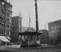
Gazebo in Pioneer Square, Seattle, 1901
Photographer unknown
1901
Image number: SHS9129
Courtesy of University of Washington Libraries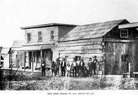
Seattle, Buildings,Yestler's Cook House, 1866
Photographer unknown
1866
Negative number: UW 5695
Courtesy of University of Washington Libraries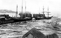
Log booms of Yesler Mill
Photo by Curtis, Asahel, 1874-1941
1878
Negative number: UW12510, A. Curtis 59756
Courtesy of University of Washington Libraries