Tsunamis
Tsunamis are huge ocean waves generated by undersea
earthquakes. Over the last 50 years, tsunamis have killed more people
than the earthquakes that caused them.
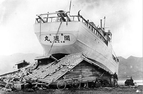 |
Japanese boat on top of house
The fishing boat No. 13 Good Luck was washed by a tsunami onto
a house in Japan. 1960. |
Jet-speed waves
Because 80% of the worlds earthquakes occur along the Pacific
Rim, most tsunamis are generated in the Pacific Ocean. Underwater
earthquakes cause sudden changes in the sea floor, sending waves
racing through the water. Tsunami waves have been measured at speeds
up to 800 km (500 miles) per hour. When tsunamis reach shallow water
near the coast, the water gathers itself as waves up to 65 m (200
ft) high. Wave after wave floods the shore.
With nothing in the way, tsunamis can travel all the way across
the Pacific Ocean and still be dangerous when they reach land on
the other side. In 1960, the east coast of Japan was devastated
by tsunami waves that had traveled from Chile 10,000 miles
in 22 hours. These same waves caused destruction all along the west
coast of North America and around the Hawaiian Islands.
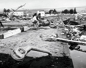
Hilo parking meters twisted
Hilo, on the island of Hawaii, was devastated by the same
tsunami caused by the 1960 quake in Chile. The wave traveled
14 hours to hit Hawaii. |
 |
Preventing disasters
We cannot predict earthquakes, but once there has been a large
underwater earthquake, we can predict that there will be a tsunami.
An international tsunami early-warning system for the entire Pacific
Rim was set up in Hawaii. Whenever a strong earthquake occurs,
instruments detect whether a tsunami was generated. A warning is
sent out to evacuate people from low-lying areas.
Experts are helping coastal communities in Oregon, Washington,
and British Columbia plan for tsunamis. For example, researchers
are mapping those areas likely to be flooded by tsunami waves. This
kind of information alerts residents to potential dangers, and helps
in planning the best evacuation routes. Such detailed maps also
show engineers where they must build to withstand wave forces, or
where they must select higher ground.
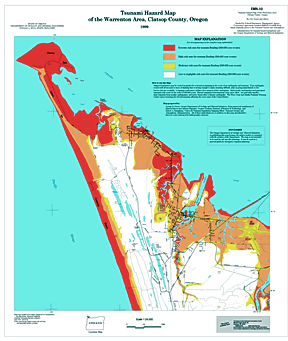 |
Tsunami hazard map of
mouth of the Columbia River (Warrenton, Oregon). Red indicates
areas of extreme tsunami danger. |
|